
By SETH J. FRANTZMAN
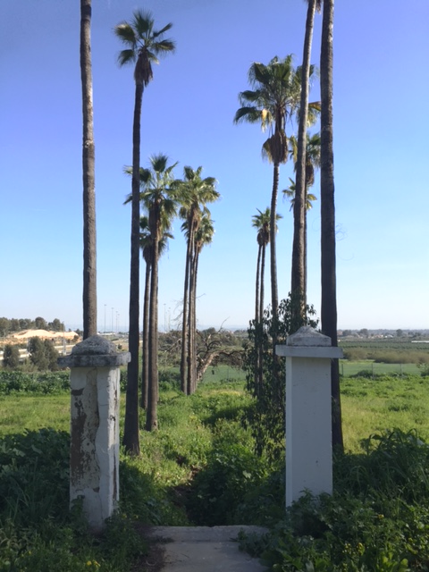
The old pathway and palm trees at Bir Salem (Seth J. Frantzman)
Anyone driving down the 431 towards Rishon LeTsiyon can’t miss the strange old buildings that loom over the highway near the exit to Be’er Yaakov. This is the coastal plain; a railroad snakes under the road. It is a reminder that this land is dotted with many old buildings and sites that have not gained fame because they are not archaeological treasures, but of recent origin. The “Allenby farm (Havat Allenby)” is one such place. Take an exit into Be’er Yaakov and a series of right turns will take you back over the highway. Before entering the kibbutz of Netzer Sereni. The kibbutz is named for Enzo Sereni, a member of the Jewish brigade and a paratrooper who died in 1944 in Dachau at the hands of the Nazis.

The school dates from 1912 (Seth J. Frantzman)
The overgrown area of Allenby farm is today used for events, such as weddings. But visitors can wander around the semi abandoned buildings. The signs brag that the place was built in 1912; but it dates from an earlier period. Johann Ludwig Schneller, founder and director of the Syrian Orphanage in Jerusalem first came upon this spot in the 1870s. He sought to acquire 5,600 dunams and built an agricultural estate and school. It took years of work, finally resolved after the German Kaiser visited Palestine in 1889. He established a farm at the place named Bir Salem. In 1906 Syrian orphans were brought to the place and housed in the buildings one sees next to the school, which looks like a church. One can see the long row of palm trees and the ruined gates, showing how the orientation of the site faced east in the old days. The school was completed in 1912, which is the date that is now given for the founding of the place. At the same time Meir Dizengoff help established the Jewish settlement of Be’er Yaakov nearby. In those days there was some coexistence between the industrious Germans and the Jewish Zionist immigrants who were both trying to develop the industry and agriculture of Palestine under Ottoman rule.
With the outbreak of the First World War the Ottomans established a military camp next to Bir Salem. They were allied with the German government and the ample water supply and stout buildings that Schneller had constructed served the Turkish army well. However by Christmas of 1917 the British general Edmund Allenby had invested and taken Jerusalem. In January of 1918 he moved his headquarters to the school building. From that point the name was connected to the British general and liberator of Palestine. The site continued under British and German patronage up until 1939 with the outbreak of World War Two when the last Germans there were interned along with other German citizens in Palestine. Royal Engineers and other British military used the site through to the outbreak of the Israeli War of Independence in 1948. During the war the 476 Arab tenant farmers who lived in barracks on the site were forced to flee. After the war as part of a reparations agreement governing Templar property Bir Salem’s assets were transferred to the kibbutz.
What is interesting about Bir Salem is how it shows the transition from Ottoman to Israeli rule and the impact of other groups on the landscape. The way it has been left in ruins, with houses falling apart, roofs in a state of collapse and the school building closed up, shows the sorry and unfortunate abuse of history and neglect of the past by the present authorities. People frown on the German and British connection. One can’t even find any British or German markings, so dutifully they were removed (unlike at Schneller in Jerusalem, where one can see the old names on the buildings). 
The next stop on our tour takes us down the 431 as it merges with the 20 heading to Tel Aviv. Take the exit onto the 44 heading towards Ramle. You’ll see a small statue of a man meeting two other men on horse on the right. Stop on the side of the road. The old gate here to Mikveh Israel is closed, but one can see the palm tree lined road that was obviously the old entrance to a beautiful estate.

The old gatehouse
Founded in 187 by Karl Netter of the French Jewish Alliance Israélite Universelle, it was supposed to be an agricultural school to help Jews learn to farm and return to the land. The Ottomans gave the Jewish organization 750 acres. Baron Edmond James de Rothschild contributed to the upkeep of the school and a wine cellar was built in 1883. This was part of the network of Rothschild settlements that were constructed at the time. One can see the old gate and stone structures. The statue of Theodor Herzl commemorates his meeting with the German Kaiser in October of 1898 at this exact location. David Ben-Gurion eulogized the importance of Mikveh Israel, claiming that without this little community the State of Israel might not have been born.
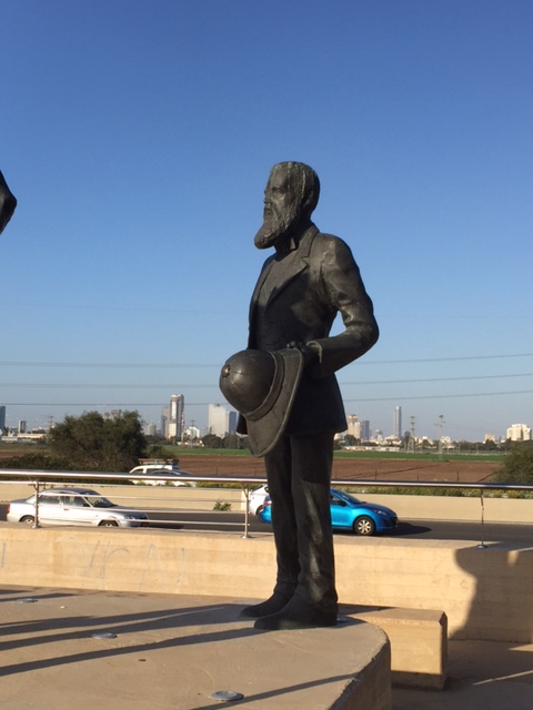
The Herzl statue
As with Bir Salem and Beit Allenby we see here this fascinating intersection of history, the importance of agriculture. The Jews here faced the same issue Schneller did in obtaining permission to own the dunams and both struggled to establish an agricultural presence. And both are interwoven with the Kaiser’s visit. As with the Allenby site, this area is neglected and overgrown.
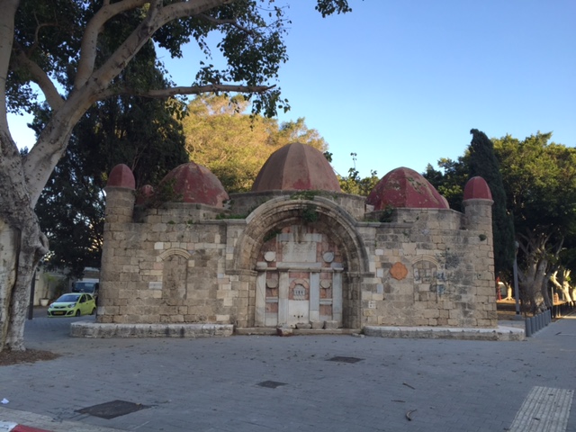
A short drive towards Ramla reveals another interesting site. Hidden behind a white wall from the highway, one should enter into Azor and take a right turn until they come to the Sha’arei Tzion synagogue. Also known as the “synagogue of the 9 domes”, this is actually the old tomb (‘makam’) of the Imam Ali. Why was the Imam Ali buried here? It isn’t clear. There were other shrines in Ottoman Palestine devoted to the Imam Ali, the cousin and son-in-law of the Prophet Mohammed. Ali is revered particularly in Shia Islam. But his presence and tradition stretched to Palestine, even though the country here was predominantly Sunni. The structure dates from before the 16th century. Is there some theory that it dates from the period of Fatamid rule in Palestine in the 11th century? That seems far fetched. We know that another shrine in the area of the Arab village of Yazur (where the Imam Ali’s tomb was found and for which Azor is named) was built on a Crusader ruin. The nine-domed shrine however is unique and was recognized by travelers of being special.
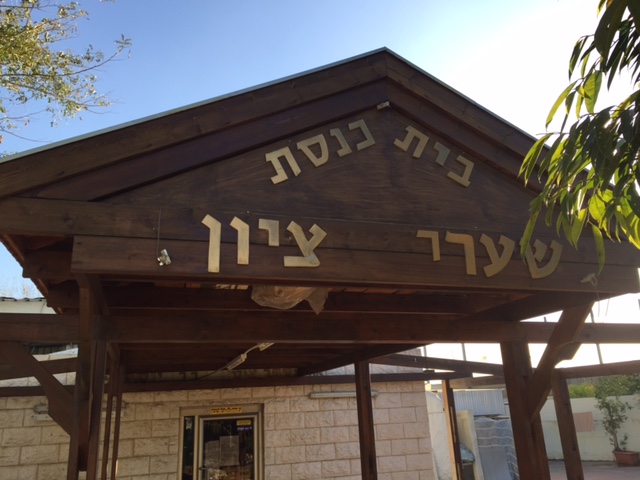
Synagogue entrance
Visitors can walk around the structure today. The synagogue seems to be closed often; but perhaps one can find a way in. Whatever Islamic era inscriptions were on the building are today hidden behind new paint jobs and various junk and sheds erected around the shrine. The villagers who once lived at this site were in constant struggle with the Jewish residents of Mikveh Israel in the 19th century.

The shrine of the Imam Ali
Taking a right turn out of Azor back onto the 44 towards Tel Aviv, the road soon turns into ‘Derech Ben-Zvi’ named after the second President of Israel. Just after Herzl street on the right is a small park named Abu Nabut garden. It is named for Mohammed Abu Nabbut, who was governor of Jaffa from 1807-1818. A protege of Ahmed Jazzar, the famous ruler of the Galilee, Nabbut was a mamluk or slave originally. He embarked on a major building program around Jaffa, renovating the Great mosque and building two major fountains (‘sabil’) in the area. The purpose of the beautiful and unique sabil here on Ben-Zvi street was to aid travelers taking this well worn road to Jerusalem. This road stretched, as it does now, toward Ramle, from where a traveler might rest and then move on towards Bab-el-Wad where there is a Turkish fort and a caravanserai or khan (near the gas station on route 1). So the traveller would have passed this fountain before reaching Mikveh Israel and Yazur’s shrine of the Imam Ali, which we just saw above.
Sabil Abu Nabut (Seth J. Frantzman)
The beautiful fountain is of a unique architectural heritage that reminds of Gaudi. Most travelers in the 19th century marveled at it and there are many well known prints and photos of it from the period. It is not the only sabil like this, there is another beautiful one in the ‘shuk hapishpashim’ and another 5km north of Yavne on the 4. A sign on the fountain says it was built in 1820 but the consensus is that it was built before that. Either way, there is a nice park nearby for a picnic. The sabil is a true reminder of the Ottoman past.

Arab inscription on the fountain (Seth J. Frantzman)
Perhaps this tour could be done in the opposite direction, beginning with the fountain to discuss the Ottomans and then seeing the nascent Jewish agricultural settlement, the shrine and then Allenby’s farm. Chronologically that might make more sense. What makes the most sense is seeing this history of the 19th and early 20th century is alive today and even if it is abandoned and neglected, it is an essential piece of history.

The old entrance to the Allenby church near Rishon (Seth J. Frantzman)
